
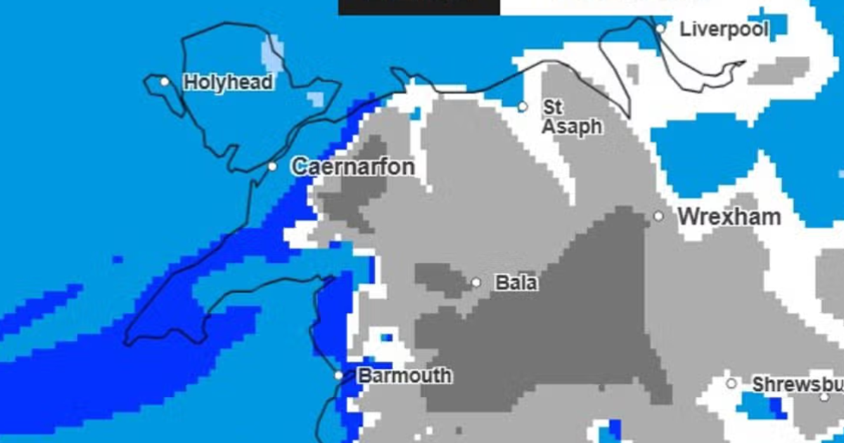
Wales faces its first significant snowfall of the winter next week, according to Met Office forecast maps showing a cold front arriving from the south-west on Monday, November 16. Overnight temperatures are expected to fall below freezing across much of the country this weekend, with lows of around -5C in places.
The wintry weather is forecast to begin around 3pm on Monday, initially affecting areas north of Swansea and around Aberystwyth, before spreading northwards to Gwynedd, Denbighshire and Conwy by early evening. Snow could reach Wrexham and Flintshire by around 9pm, with some areas seeing more than 4mm of precipitation an hour.
What the Met Office maps show
The forecast, first reported by WalesOnline on November 13, suggests North Wales will bear the brunt of the snowfall. By midnight on Monday, the heaviest precipitation is expected to sit over parts of Conwy, Flintshire and Denbighshire, raising the prospect of disruption along the A55, the main arterial route along the North Wales coast.
Snow is then forecast to continue into Tuesday morning, November 17, before conditions begin to clear between 6am and 9am. Further south and along the west coast, the maps indicate scattered wintry showers, with patches of snow possible north of Swansea and around Aberystwyth.
The Mirror has reported that the same weather system could bring snow to as many as 20 counties across England, Wales and Scotland early next week, alongside wintry showers expected this weekend across Britain.
A sharp frost before the snow
The Met Office has already warned of a sharp overnight frost across much of England and Wales on Friday, urging the public to prepare for plummeting temperatures.
Tonight may be the night to swap to the winter duvet (if you haven't already)!
In its social media post, the forecaster said the frost would develop in the countryside across much of England and Wales, while Scotland and Northern Ireland would see less widespread frost due to cloudier skies. The colder conditions are expected to become more widespread as the new week begins, with temperatures potentially falling close to freezing in many parts of Wales.
Why is snow so difficult to forecast?
The Met Office has been candid about the challenge. Snow, it explains, requires two key ingredients: cold air and moisture. A northerly airflow can bring colder Arctic air towards the UK, while easterly winds can draw cold continental air from Europe. If that cold air encounters moisture, whether from a weather front or showers developing over the sea, precipitation has a greater chance of falling as snow.
Relatively small changes in temperature and wind direction can determine whether precipitation falls as rain, sleet or snow. Heavier precipitation can cool the air close to the surface, sometimes allowing snow to reach the ground, while lighter snowfall can melt before it settles.
The forecaster combines high-resolution computer models with radar observations and expert judgement to refine its predictions. The distinction between snow falling and snow settling matters, it notes, because even small amounts of snow or ice can affect transport networks, infrastructure and everyday journeys.
What this means for public services and travel
The exact timing, location and amount of snowfall could still change before Monday. Confidence in where snow will fall, and whether it will settle, generally increases closer to the event. Where snow has the potential to cause disruption, the Met Office can issue National Severe Weather Warnings to alert the public and the organisations responsible for transport and road treatment.
The Daily Post has reported that snow could fall for more than 12 hours in parts of North Wales, a duration long enough to test the resilience of local road treatment and public transport networks in the region. Residents across Wales are being advised to monitor the latest forecasts, particularly those planning journeys early on Tuesday.
For a country that has learned, sometimes painfully, the cost of underestimating weather events, the lesson bears repeating: preparation is not alarmism. Local authorities will be judged by how they treat their roads and support vulnerable residents in the days ahead, and the public should expect clear, timely communication. Early warning systems exist precisely so that disruption can be managed rather than endured; the coming days will show whether they are used to full effect.
Frequently asked questions
When is snow forecast to fall in Wales?
According to Met Office forecast maps, snow could begin falling at around 3pm on Monday, November 16, initially north of Swansea and around Aberystwyth, spreading to North Wales by the evening and continuing into Tuesday morning, November 17.
Which parts of Wales will see the most snow?
North Wales is currently expected to see the most significant snowfall, particularly Gwynedd, Denbighshire, Conwy, Flintshire and Wrexham, with lighter patches forecast further south.
How cold will it get?
Overnight lows are expected to hover around -5C in many areas this weekend, with temperatures potentially falling close to freezing more widely as the new week begins.
Will the snow disrupt travel?
The Met Office has warned that even small amounts of snow or ice can affect transport networks, and there could be implications for travel along the A55. National Severe Weather Warnings may be issued if disruption is likely.